Planning flight award redemptions can be challenging, though the process has been simplified in recent years thanks to new tools that have cropped up. Some common complexities of flight award pricing arise due to distance-based award charts being used by frequent flyer programs.
These programs price partner award flights based on the actual distance that the flight will fly, meaning a flight to the same city in Asia will cost different amounts of points when flying from the East Coast or West Coast of North America. However, using a tool like Great Circle Mapper can make it easy to plan out potential routes to determine the best option and the points cost without needing to find availability.
Whether you are new to the idea of Great Circle Mapper or have played around with this tool in the past, let’s take a look at how you can better utilize it before your next award flight booking.
What is Great Circle Mapper (GCMap)?
Great Circle Mapper, or GCMap, is a free online tool that can be used to quickly and effectively calculate the flight travel distances between two airports or your desired flight route. The basic premise of the tool is that you key in your airport codes and can generate a visual map while also computing the total travel distance.
For the uninformed, it can seem like a neat tool that just provides interesting data. For miles and points enthusiasts, this is a powerful tool to assist with booking award flights in frequent flyer programs that operate distance-based award charts.
Travelers can plot out their entire itinerary before searching for award space to optimize and ensure they are landing in their desired distance bracket for their preferred points redemption cost. Great Circle Mapper also makes it easy to play around with multiple routes at once so travelers can easily compare distances of different routes to make informed redemption decisions.
The majority of data you will be entering in Great Circle Mapper will be airport codes, or you can also enter a city name if you don’t know the airport code as using the city name will prompt you with a list of nearby airports that you can choose from.
Additionally, there are four main modifiers or symbols you will be using in conjunction with these codes to generate your results:
- “–” is the dash, which allows you to link cities and itineraries together
- E.g. YYC-YYZ or YYC-YYZ-AMS-FCO
- “,” is the comma, which separates queries, but will show all queries on the same map result
- E.g. YEG-LAS,YEG-YVR-LAS
- “/” is the slash, which duplicates queries based on the first one entered
- E.g. TPE-YVR/SEA/SFO/LAX
- “@” is the at symbol, which is used to base a query around an airport
- E.g. 2500mi@YYZ
The Best Uses for Great Circle Mapper
Great Circle Mapper is a great example of a tool that is simple to use on the surface, but incredibly powerful the more you understand it.
Below I’ve listed a few ways that I like to use the tool when planning out award flight routing with distance-based award programs, to give me a better idea of potential possibilities before I start searching deeper for seat availability with the various award search tools we have available.
Calculating the Distance Between Two Airports
The most basic way to use Great Circle Mapper is to calculate the distance between two airports. Perhaps you have a potential trip in mind and simply want to determine the distance between your origin and destination to have a better idea about the award redemption pricing.
To calculate the distance, simply key the two airport codes with a dash in between. So, if I was interested in seeing how far apart Vancouver and Toronto are when traveling by aircraft, I would key “YVR-YYZ” and click “Map” to see the results.
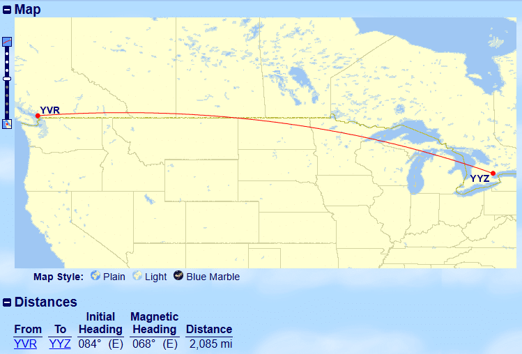
The distance between these two airports is 2,085 miles, so I can now better determine what this route would cost if I were making a redemption through the Air Canada Aeroplan program as I will be able to slot this route into their distance-based award chart.
Calculating the Distance on an Entire Itinerary
Calculating the distance between two airports is a normal approach if you are flying domestically, but if you are going international it is unlikely that your whole itinerary will only consist of one flight between two cities.
Thus, we can also use Great Circle Mapper to calculate the distance of an entire itinerary to see where it would fall in the distance-based award chart of the frequent flyer program of our choice. Calculating the distance of the entire itinerary can also help us easily compare potential routing options to ensure we are getting the most value for our points.
If I’ve been earning a glut of Air Canada Aeroplan points through my TD Aeroplan Visa Infinite Privilege card and have an interest in traveling to Japan, I would be able to consider flying on any of the Star Alliance partner airlines, and the most likely choice would be ANA business class.
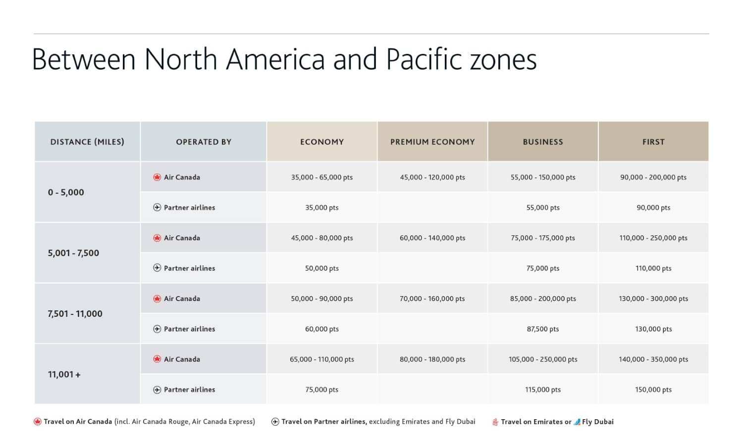
Thus, let’s take a look at the potential pricing and distance brackets for North America to Pacific Zone redemptions on the Air Canada Aeroplan award chart:
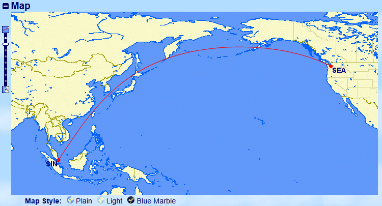
To start, I want to find the distance of my perfect itinerary if I were to originate from Edmonton, connect in Vancouver, and head onwards to either Haneda Airport or Narita Airport in Tokyo. To check this, I key “YEG-YVR-TYO” into Great Circle Mapper and click “Map” to determine the total distance.
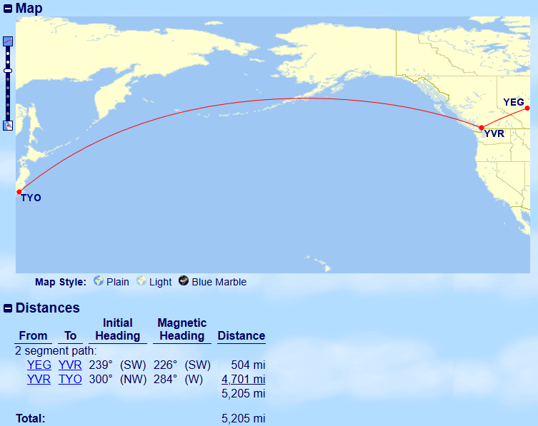
With this itinerary being 5,205 miles, it pushes me barely over the 5,000 mile distance bracket which means my itinerary will cost 75,000 Aeroplan points if I booked entirely on partner airlines. This itinerary will also be impacted by Aeroplan dynamic pricing on the YEG-YVR leg as there are no partner airlines that fly this route which means I will have to fly on Air Canada, which can increase my cost even more.
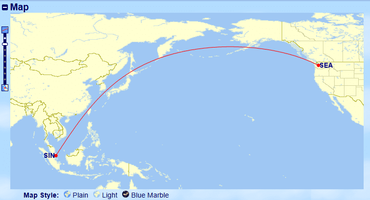
Optimally, I’d like to get below 5,000 miles to be able to book my flight with fewer Aeroplan points. So let’s cut out the YEG-YVR leg of this itinerary, which leaves us with YVR-TYO at a distance of 4,701 miles.
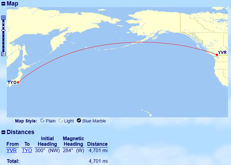
This puts us in the below 5,000 miles bracket, resulting in a lesser cost of 55,000 Aeroplan points for this itinerary in business class on a partner airline like ANA.
Of course, this still means you need to go through the work of finding availability and figuring out how to get to YVR if YEG is your point of origin. Perhaps a small WestJet Rewards redemption could be worth it, or if you like risk, booking a dirt-cheap fare on Flair Airlines could be worth the gamble. For me, if I could get an economy flight on WestJet for a reasonable amount of WestJet points, I’d rather use those than burn additional Aeroplan points, which are far more valuable.
Mapping Multiple Flights at Once to Compare
Let’s say I’ve been earning British Airways Avios by transferring RBC Avion Rewards earned on my RBC Avion Visa Infinite card. Maybe I’ve had my eye on visiting Japan, and I know that finding Japan Airlines business class availability is pretty easy via British Airways Avios if I am looking at the end of the schedule.
British Airways Avios operates distance-based award chart pricing for flight redemptions, so I know that the flights that I am interested in will fall into a specific pricing bucket as opposed to being dynamically priced. To start, I visited FlightConnections and selected “Japan Airlines” as my airline and looked at all flights from North America to Tokyo Haneda which has the airport code HND.
I can easily see that there are five airports that have routes that fly directly into HND on Japan Airlines, so I key a string of “SFO-HND,LAX-HND,DFW-HND,ORD-HND,JFK-HND” into Great Circle Mapper and click “Map” which spits out the following data including the multiple routes I specified:
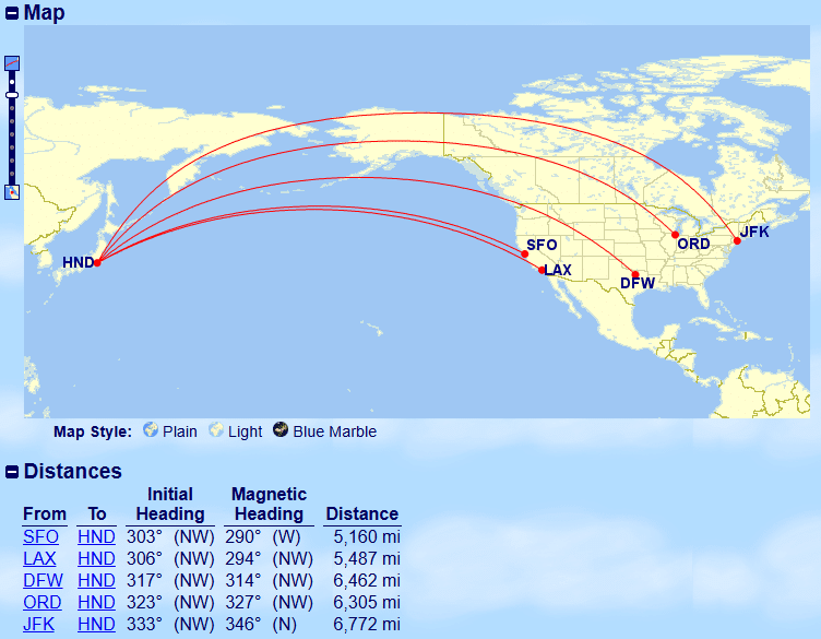
Alternatively, you could also key “HND-SFO/LAX/DFW/ORD/JFK” to get the same results with less duplication. The real value in mapping multiple flights at the same time is in the distances table at the bottom as it organizes it based on the shortest to longest distance.
I know that the Zone 6 distance band is from 4,001 to 5,500 miles and that business class flights within that band will cost 77,250 Avios plus taxes and fees. Thus, based on the table, I can see that the flight from San Francisco (SFO) makes the cut and that the flight from Los Angeles (LAX) also barely falls within that bracket.
Direct flights from the other three cities on Japan Airlines to Tokyo Haneda will be placed in the next distance bracket and will have an increased cost of 92,750 Avios plus taxes and fees, which is an additional 15,500 Avios over those flights departing from the West Coast. Depending on where your home airport is located, it can make more sense to book a positioning flight to SFO or LAX to save on redemption costs versus flying out of one of the other three cities.
Using Great Circle Mapper to map all of these routes at once makes it much easier to plan and optimize where you would consider flying out of if you were mainly interested in making a redemption for the cheapest points cost, and can set you up for success with a good starting point of airports to consider.
Determining Mileage Radius From An Airport
Great Circle Mapper can also be used to show a mileage radius around a specified airport code, which can be useful if you are interested in seeing what destinations would fall within a certain distance bracket.
Let’s say I want to go on a vacation for a few days, and am looking for a cheap points redemption to do so. For this redemption, I want to use Aeroplan points and will be departing from Edmonton, while wanting to travel less than 1,500 miles to remain within that distance band.
To display the 1,500 mile radius around Edmonton, I key “1500mi@YEG” and click “Map” to display the below results.
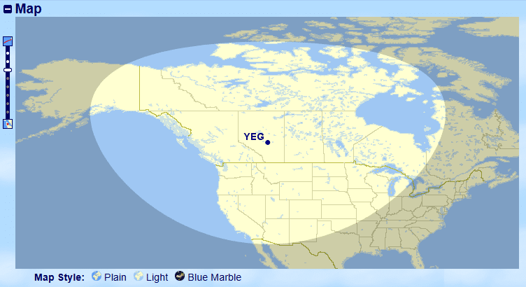
Once the radius is displayed on the map, this will continue to be displayed for any future searches.
For display purposes, I plotted a bunch of random North American cities that may or may not have direct routes from Edmonton within the Aeroplan program by keying “YVR,LAS,AUS,MCO,YYZ” and clicking “Map”.

You can see that both YVR and LAS fall within the 1,500 mile radius, whereas YYZ is just outside which means that if I wanted to fly direct YEG-YYZ, it would fall within the next distance bracket at an increased points cost.
Even if there is a connection it might still be possible to reach a destination within that distance bracket; for example, YEG-YVR-LAS is 1,496 miles, which means it still falls in the under 1,500 miles distance bracket.
As an aside, if you wanted to plan a trip using this feature optimally, it would be best to look up what direct routes are available on FlightConnections first and then throw those valid destinations into GCMap.
Optimize Further: Best Great Circle Mapper Settings
Great Circle Mapper has a ton of configurations that can be played with to make the experience more catered to your needs. The Map Controls section can be accessed at the bottom of the page and has four different tabs and the settings within that can be used to customize functionality.

While we could write an entire article on the settings alone, there are two that I always recommend users change for better usability: Projection Settings & Map Style.
Projection Settings
Projection Settings are how the map displays and the default value is “Best: Rectangular or Polar”. This means the map will automatically swap between the “Rectangular Plate Carée” and “Polar Aspect Orthographic” projection depending on what is plotted.
I prefer to change this setting to the “Rectangular Plate Carée” projection as I find it is much easier to read and my brain processes the rectangular flat map better.

The “Polar Aspect Orthographic” looks like the below and may be preferred by some, but by setting the default to rectangular I don’t end up with Great Circle Mapper flipping between the two projection choices depending on what I am mapping.

Map Style Settings
The other setting that is worth changing is Map Style. This setting can be adjusted by clicking “Plain”, “Light” or “Blue Marble” directly below the map, or within the config menu which has many more options.
The default Map Style is “Plain” which can make it difficult to read airport abbreviations, especially if mapping to somewhere near water.
In my opinion, the best and preferred Map Style setting to use is “Light” as it is similar to “Plain” but much easier to read with more muted and neutral colors while still easily displaying all desired information.
The other Map Style option worth considering is “Blue Marble” as it also presents a much more readable map than the default “Plain” option.

I find that tweaking these two settings, while minor, makes GCMap much more usable in its basic form. If you want even more customization, play around with the other settings as well to make your Great Circle Mapper experience your own.
Conclusion
Great Circle Mapper is a tool that every award traveler should be aware of and utilize, especially since many of the popular frequent flyer programs for Canadians utilize distance-based award charts.
For those who are points-conscious when making bookings, comparing and understanding flight distances before searching for award space in these programs can eliminate departure cities that don’t fit in your points redemption budget.

Josh Bandura
Latest posts by Josh Bandura (see all)
- New Scotiabank Credit Card Offers for July 2026 - Jul 2, 2026
- Best Cash Back Credit Cards in Canada for July 2026 - Jun 27, 2026
- Transferring Avion Points: What’s Your Best Option? - Jun 26, 2026
- Using Qatar Avios for Bangkok Airways to Koh Samui: A High-Value Sweetspot - Jun 15, 2026
- Earn Cash Back Rebates on Tangerine Credit Cards – New Card Added! - Jun 9, 2026